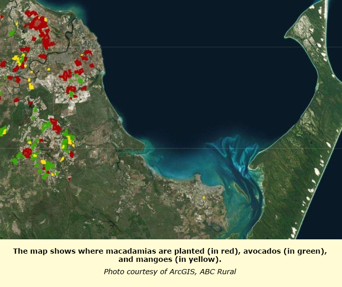
For the first time, Australia’s mango, macadamia, and avocado crops have been mapped.

It’s a move that authorities say will change the way government and industry deals with natural disaster responses and disease outbreaks.
The Australian Tree Crop Rapid Response Map is available online and is a collaborative project involving state and federal government agencies, four universities, and industry bodies.
The data took more than 12 months to gather using satellite images, industry information, and ‘citizen data’ collected via a specialised app.
Rapid response to natural disasters
The multi-million-dollar project has been led by Associate Professor Andrew Robson from the University of New England’s Precision Agriculture Research Group.
He said the map had already been tested with positive results.
“It is used for post-disaster monitoring such as Cyclone Debbie that occurred in March and the recent horrific storm that went through Bundaberg that affected a lot of Macadamia orchards,” Professor Robson said.
After a natural disaster the tree crop map would be overlaid with a map of the weather event to determine which crops would have been damaged.
Professor Robson said this method was used after the Bundaberg storm to pinpoint the damage.
“We very quickly scrambled for high resolution imagery to be captured, to compare to old satellite images and capture very quickly the damage, to even tell which individual trees were affected,” he said.
This information will be helpful to industry bodies, responders, insurance companies and even growers if they are unable to reach crops to assess the damage themselves.
Fast containment of disease outbreaks
The map would also help inform management during disease outbreaks.
“It’s available to the federal government’s bio-security so in the event of an outbreak in any of these orchards a quick response can be organised because you know where the orchards are, so exclusion zones and where to send surveillance staff,” Professor Robson said.
Queensland avocado and mango grower Chad Simpson was excited by the potential of the map.
“It’s probably knowing, the reassurance that there is something in place if there is a biosecurity outbreak or natural disaster system,” he said.
Plan to expand map to give growers variable yield data
For its current purpose Mr Simpson hoped the map was something nobody would ever have to use but it had potential beyond managing agricultural disaster.
The map was part of a greater project that aimed to provide growers with data to understand the variability in their crops, and to inform decisions such as irrigation and fertiliser usage.
Professor Robson said the larger project was inspired by the Queensland sugar cane industry’s extensive data mapping.
“They identify the different varieties, grower information, yields and that’s held under strict confidentiality with the growers and the mills,” he said.
“But working with that and seeing the potential to know as a database to know yield variation, spatial variation and temporal variation of yield across regions and across blocks was unbelievably powerful.”
The map could also expand to include more crops with the citrus, olive and pineapple industries watching the results of the project closely.
Written by Olivia Calver and Lisa Herbert
Source: ABC Rural
